UN
28 Springfield Road
£ 154,950
Description
We don't have a Description for this property.
- Bedrooms
- 1
- Bathrooms
- 0
The heatmap indicates the level of crime in the area. The color of the heatmap indicates the crime severity and recency.
Metrics Year-on-Year
- Average area value
- 486,436.00 £Decreased by 5.02 %
- Average area rental value
- 2,169.00 £/moIncreased by 24.58 %
- Est rental Yield
- 5.35 %Increased by 31.13 %
- Crime Rate
- 2.00 %Unchanged by 0.00 %
from 512,164.00 £
from 1,741.00 £/mo
from 4.08 %
from 2.00 %
Nearby Schools
| Name | Type | Ofsted | Distance |
|---|---|---|---|
| Preston Park Children'S Centre | Children's Centre Linked Site | 0.45 KM | |
| Brighton & Hove Montessori School | Other Independent School | Good | 0.69 KM |
| St Bartholomew'S Cofe Primary School | Voluntary Aided School | Good | 0.70 KM |
| Stanford Junior School | Community School | Good | 0.72 KM |
| Downs Junior School | Community School | Outstanding | 0.82 KM |
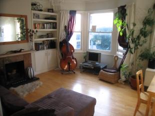
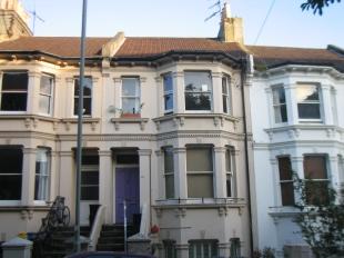
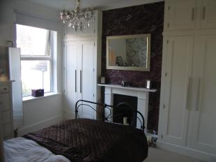
Images
Nearby Streets
| Name | Average Price | Average Sqft | Distance |
|---|---|---|---|
| Circus Parade | £ 0 | 0 | 0.00 KM |
| New England Road | £ 0 | 0 | 0.00 KM |
| Isetta Square | £ 0 | 0 | 0.00 KM |
| Blackmore Court | £ 0 | 0 | 0.00 KM |
| The Open Market | £ 0 | 0 | 0.00 KM |
Nearby Transport
| Name | NLC | TLC | Distance |
|---|---|---|---|
| London Road (Brighton) | 5281 | LRB | 0.52 KM |
| Brighton | 5268 | BTN | 0.80 KM |
| Preston Park | 5285 | PRP | 1.89 KM |
| Moulsecoomb | 5312 | MCB | 2.73 KM |
| Hove | 5273 | HOV | 3.27 KM |
Nearby Listings
| Address | Price | Type | Score | Distance |
|---|---|---|---|---|
| Springfield Road, Brighton | £ 265,000 | BUY | 4 / 10 | 0.00 KM |
| Springfield Road, Brighton | £ 382,500 | BUY | 6 / 10 | 0.01 KM |
| Springfield Road, Brighton | £ 290,000 | BUY | Unknown | 0.03 KM |
| Springfield Road, Brighton | £ 325,000 | BUY | Unknown | 0.03 KM |
| Springfield Road, Brighton | £ 325,000 | BUY | 5 / 10 | 0.05 KM |
Nearby Properties
| Address | Price | Distance |
|---|---|---|
| 44b Springfield Road | £ 234,000 | 0.00 KM |
| 28a Springfield Road | £ 192,000 | 0.00 KM |
| 42 Springfield Road | £ 164,500 | 0.00 KM |
| 38a Springfield Road | £ 280,000 | 0.00 KM |
| 12a Springfield Road | £ 289,950 | 0.00 KM |